Pages

Monday, August 22, 2016

Turn geotagged Flickr Albums into KML

I was looking for an easy way to add geotagged photos that I had stored in Flickr to an ArcGIS web map. While geotagged photos, hosted or not, can't currently be directly imported into an ArcGIS web map, there are several different paths you can take to accomplish the task.

One of the ways is to convert the geotagged photos in a Flickr album to KML, A quick Google search turned up a post at AdamFranco.com - Flickr Photo Set to KML. Click Photo Set to KML in the post to open the web utility.

First put the desired geotagged photos into a Flickr Album (formerly a Flickr Set). Next, open the album and obtain the album ID from the URL:


Copy the album ID and paste it into the KML utility, then click Submit:


The KML will be processed, and downloaded. Once downloaded you can add it to your ArcGIS Online account, then add it to a web map. You can also use the KML in Google Maps, Google Earth, ArcGIS Earth, or any other application that supports KML.

Tuesday, July 19, 2016

2016 Story Map Contest Winners

Story Maps combine interactive maps and multimedia content into elegant user experiences. They make it easy for you to harness the power of maps to tell your stories. They've come a long way since first released, and this year's contest winners up the bar in storytelling with maps. At the recent 2016 Esri User Conference, the Storytelling with Maps Contest winners were announced and posted on the Story Maps website. You'll get some great ideas and learn from these excellent examples that use a variety of different story map templates.


For more info see the Story Maps website.

Tuesday, December 2, 2014

An interactive perspective on Comet 67P and Auckland

Comet 67P/Churyumov-Gerasimenko could have been just another unknown hunk of galactic stuff traveling through the enormity of space. According to Wikipedia it was discovered in 1969 by Klim Ivanovych Churyumov who identified it by working off of photographs taken by Svetlana Ivanovna Gerasimenko, who was shooting for a different comet. Even so, were it not for the fact that the 2.5-mile diameter comet became the target for the European Space Agency Rosetta mission, it would still have remained in obscurity. The historic mission, launched in 2004 and making its rendezvous with the comment earlier this year, became the first to ever land a space probe on a comet, subsequently creating a fascinated global audience. I ran into a blog post about how the comet is being compared to cities worldwide using digital wizardry. But even more interesting is this Esri City Engine Web Scene authored by Zorko Sostaric of Eagle Technology in Auckland, New Zealand.


For a few more details, including links to the actual web scene, see the related GeoNet blog post.

Monday, November 17, 2014

The geography of our favorite pollinators

A new Esri Story Map released today now ranks as one of my all-time favorites, perhaps because I love macro photography, my Dad was a beekeeper, and I'm a biologist at heart (and by degree). Geography Bee: A Global Gallery of Pollinators uses the context of geography to introduce us to the fascinating world of bees using the incredible photographs of USGS naturalist Sam Droege (whose images can also be enjoyed at his Flickr gallery).


The Story Map is also a preview of a new configuration that will soon be available for the Story Map Tour, currently the most popular Story Map template. Browse the Story Maps Gallery to find more interesting map-based stories.

Tuesday, August 19, 2014

Esri Storytelling With Maps Contest Winners

Story maps combine interactive maps and multimedia content into elegant user experiences. They make it easy for you to harness the power of maps to tell your stories.

At the recent Esri User Conference, the Storytelling with Maps Contest winners were announced and posted on the Story Maps website. You'll get some great ideas and learn from these excellent examples that use a variety of different story map templates.


Thursday, July 31, 2014

A Few Clicks to Understanding California's Drought

Unless you've been on vacation and off the grid the last few days, you've likely seen the coverage of the massive 30-inch water main break on Sunset Boulevard near the UCLA campus in the Westwood neighborhood of Los Angeles. The break has spewed over 20 million gallons of water, flooding UCLA buildings, creating a massive sinkhole in the street, and heightening awareness of the fact that California is suffering through a drought of epic proportions.

As this map from the U.S Drought Monitor shows, most of the state is currently under extreme or exceptional drought conditions.


I discovered this Story Map a few weeks ago, and it drives home in just a few clicks - one actually - how low this year's water levels are compared to three years ago - click once to advance the tour and see for yourself.


You can view the entire Story Map Tour, authored by the Metropolitan Water District of Southern California (MWD), to learn and see more. Zoom in to see where the photos were captured. This very simple, yet effective application tells the story in just a few clicks.

Saturday, August 25, 2012

Are You One in a Million?

Are you one in a million? As it turns out, you're definitely not. More like one in 314 million or so. Here's the US Census Bureau's population estimate at their headquarters in Suitland, Maryland (just outside Washington, D.C.). The photo was taken a while ago, as the out-of-date population estimate indicates.


For the current population estimate check out the U.S. and World Population Clocks.

Here's a few ArcGIS Online maps that provide more information about US population. Zoom in or out to view more detail, and click any feature for more information.

EZ Ways to Map GPX Files on the Web

This evening I was looking at some Web apps to map GPX files. There's lots of different alternatives, and here's few that I like that you can choose from.

ArcGIS Online

Using the 
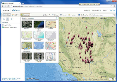
ArcGIS.com map viewer you can quickly and easily map your GPX files. It's free to use, and free to get a public account, so you can save your maps and share them with others. Using ArcGIS Online's tools you can use the maps you make in templates, embed them in websites or blogs, share them via links, and more. It's by far the best way to map your GPX data online. You can choose from a variety of different basemaps, and also search for additional layers to add to your map from other users and the GIS community.

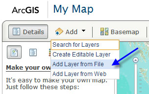
First, open a new map and click Add, then choose Add Layer from File:


Navigate to your GPX file and select it to add it to your map. You can choose from a variety of different basemaps, change symbols, and configure the pop-up for each GPS location. Here's our GPX file shown in the ArcGIS.com map viewer:

Click to view larger image
For more information, tune in to the ArcGIS Online community on the ArcGIS Blog.

GPS Visualizer

This site provides a great set of tools and options that not only let you create a quick map of your GPX data, but also provide lots of options like export (to KML or a variety of image formats), HTML generation to embed your map in a website or blog, view your data in Google Earth, and a lot more.

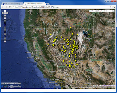
Here's the same GPX file as shown above that we exported to an HTML document. A few quick edits in Notepad and we were able to easily expand the map and change the symbols.

Click to view larger image
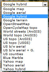
Another very nice feature are the basemap options. Everything from ArcGIS Online basemaps, to Google, to Yahoo, and others are available for you to choose from. Here's the drop-down list of available basemaps:


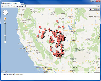
GPS GPX Interactive Map

Chris Lacy's website includes an app that provides a handy way to make a quick and easy Google map using your GPX file. Just open his default map, click Choose at the bottom of the page, and navigate to your GPX file to create a quick Google map. The app uses the Google Maps API, and while it's not necessarily intended for saving your map or sharing it with others, it does provide a quick way to visualize your data without any fuss. Basemap options include all the Google ones; Map, Terrain, and Satellite (with and without labels).

Click to view larger image

The above are just a few options that I've found. You can also convert your GPX file to a KML or KMZ file for use in Google Maps, ArcGIS Online, ArcGIS Explorer Desktop, ArcGIS for Desktop, and more. We'll consider some of these options in another post.

Thursday, October 13, 2011

Thailand Flood Map

Earlier this evening I caught a tweet about this map showing flooding in Thailand. While I don't read Thai, it's obvious by "reading" the map the disastrous flooding going on. While not the most elegant map, it's yet another example of how maps communicate universally.

(click to view larger image)
The application is familiar; it's based on a template built by Esri Technical Marketing that's available on ArcGIS Online.


Using templates like these with readily available basemaps and open APIs and services, it's easier than ever to stand up a custom application like this one in response to disasters and other events.

Wednesday, August 24, 2011

A Tip For Adding Geotagged Photos To ArcGIS Online Webmaps

Recently someone asked if they could add geotagged photos to their ArcGIS Online maps using the ArcGIS.com map viewer or ArcGIS Explorer Online. Currently these are not directly supported, but here's a way I found to add them using an intermediate step or two.

Geotagged photos have all you need to add them stored in the EXIF formatted data in the image. And ArcGIS Online webmaps support adding features to your map via a CSV file. It's easy to open a photo in a pop-up window from some Web location. With all that in mind, the only challenge was to find an easy way to extract the XY coordinates and get everything into a CSV file.

My plan was to copy the geotagged photos to some Web location, and create a CSV file with both the XY coordinates and the URL of each photo. If I could manage that, I could simply drag-and-drop (or import) the file onto my map to add points, and configure the pop-up for each point to display the photo.

After some Web searching I found a solution from BRSoftware called EXIFextracter. It's currently in beta with a final release coming soon, and a pro version also coming up on the horizon. After downloading and installing it I found it to be just the ticket for my needs. I could point to a folder of geotagged photos, choose what information I wanted to extract from each photo, and export the information directly to a CSV file including the filename. Great!

Here's the EXIFextracter dialog for choosing the folder, output CSV, and data:

(click to view larger image)
I tried this on several folders containing geotagged images, and the export worked perfectly. The only complaint I had is that I would have liked to see the field names in the first row for the data I extracted, but they were easy enough to add. Another minor issue was that some of the data I chose came across as empty or otherwise unrecognizable, though to be fair the photos were a combination of in-camera geotagged files of various vintages and some photos that were geotagged using other utilities.

A couple of other things that I did - I copied the photos to a URL location, and also edited the CSV file to add the URL location for each file. Here's my edited CSV with the first row containing field names and the updated file locations, lat/long, and date stamp following:

(click to view larger image)
From there, I just dragged and dropped the CSV file onto my map, and configured the pop-up to display the photo from its URL location. Here's the photos in my map (shown using Explorer Online):

(click to view larger image)

Sunday, July 24, 2011

ArcGIS Online via Google Search - Myth Busted!

Recently someone told me that items shared on ArcGIS Online could not be discovered via a Google search - but exactly the opposite is true. Anything shared publicly in ArcGIS Online is searchable using popular search engines like Google and Bing, though depending on how results are ranked your match mileage may vary.

For example, searching for usa tapestry segmentation will currently show the first ArcGIS Online matches at 4th and 5th in the search results:


The URL endpoint for shared ArcGIS Online items is actually from the arcgis.com website. The surefire way to search for publicly shared items is to use the site: keyword that Google search supports. Entering something like site: arcgis.com followed by a search string will search for that specific string at arcgis.com and return the publicly shared ArcGIS Online items that match:


Google search will typically only return a subset of what you can find directly via an ArcGIS.com search. Why? I'm not entirely sure. So for best results go directly to ArcGIS.com, but clearly the myth that public ArcGIS Online items can't be searched via Google is busted!