Pages

Monday, May 2, 2011

Using ArcGIS Explorer Desktop for KML Spatial Query

Here's another sneak peek at some soon-to-be-released functionality that will be delivered with ArcGIS Explorer desktop, build 1700, due out in about a month.

Below we've added a KML showing NOAA Snotel gauging stations to Explorer. We also created a 20-mile buffer around the peak of Redtop Mountain, just north of Crater Lake. The buffered area (shown in orange) was used in a spatial query to select the NOAA Snotel gauging stations in the KML falling within the buffer distance.


The results of the query can be added to your map as notes, and saved as layer packages for use in ArcGIS Desktop. ArcGIS Explorer Desktop can already export any KML as a layer package, and can also convert any layer package to KML.

Tuesday, April 12, 2011

Testing New GPS Tools in ArcGIS Explorer Desktop

We've been working on a new release of ArcGIS Explorer Desktop (which will be labeled build 1700 - to be released sometime at the end of May) for a while now, and one of the new features that we'll be adding is direct GPS support. We don't often post about futures on the official Esri ArcGIS Explorer Desktop blog, and I had such a fun time this evening driving around and exercising this new capability, so I thought I'd share the results here, unofficially.

I took the long way home using a USB GPS receiver I borrowed from a colleague (only $18) and ArcGIS Explorer in disconnected mode on my laptop which I placed on the seat next to me. Once the GPS receiver was plugged in, I could begin receiving locations and could capture waypoints at the click of a button, or set Explorer to capture waypoints, tracks, or both at regular intervals automatically.

Below is the map in 2D, showing the waypoints and tracks collected along my drive. I set the collection to automatic, grabbing a location every 10 seconds. As I drove along I could view my current location as a blue dot, and could center the map as I moved.


Once captured, the GPS waypoints and tracks are stored as notes. The lat/long and elevation are automatically added to the note popup along with the date and time.


Below are my travels shown in 3D mode. The green flags are waypoints I collected via a click, and the yellow flags and tracks were collected automatically every 10 seconds.


I'm certain this will be a welcome new addition to ArcGIS Explorer.

Monday, March 28, 2011

Exploring Buildings Virtually (or Geodesign in Miniature)

I stumbled upon an application from FloorPlanOnline that targets the real estate market, but I think has potential applicability for many other domains. While doing some online house-hunting I came across a listing that included a great virtual real estate tour. The first thing that caught my eye was a map; actually a floor plan that showed the locations of photos taken at various places in the condo. I could click to see what things looked like from each location, and the icons changed color as I visited the photos; red was not viewed, green were those I had seen, and blue was the location of the current photo shown in the panel in the upper left.


I could also check how things looked when fully furnished by choosing objects from several menus with categories like bedroom, living room, kitchen, and also animals and garden objects. I could even drag and drop a golden lab in front of the fireplace (but somewhat disappointingly, could find no cats). Here was "GeoDesign" in miniature.


I've struggled to get similar floor plans and many other related kinds of maps into a GIS where I could manage objects that include links to photos, reports, and other media in a geodatabase. The struggle is that using a GIS all this works best if you georeference what you want to work with - a floor plan, a cave map, a site map for an archaeological dig - even if it makes no sense to do so, and your basemap is lower in resolution than the map you want to manage and (often by necessity) need to georeference.


I've evolved some workarounds to avoid the need to georeference maps of these types. But this is where I think GIS can take a lesson from CAD drawings - why can't we have a "paper space" projection that just treats scanned maps or vectorized diagrams in scaled page space, rather than UTM zone 12 or web mercator auxiliary sphere?

Wednesday, March 23, 2011

Most Popular Browser (subject to change)

Chrome has been my browser of choice for quite a while now, and a recent news item about the popularity of Firefox among Windows users still parked on Windows XP led me to an interesting link from netmarketshare.com which shows how things shake out today in terms of popularity.


As of today the current marketshare trend shows Internet Explorer decreasomg, Firefox holding steady, but Chrome coming on strong. We'll see how things shake out over time, but it seems I'm among a growing number of Chrome-o-philes.

Tuesday, March 8, 2011

The Most Popular Mobile Platform at the Esri DevSummit

Tom Brenneman, a colleague from Esri St. Louis, used a clever technique to judge the popularity of mobile platforms at the 2011 Esri DevSummit at the Palm Springs Convention Center today. He used an iPhone app that displays decibel levels, and had attendees cheer and applaud for the platform they were planning to use for mobile development. These were recorded during a session titled "Choosing a Mobile Deployment Platform."

Tom's website posted these snapshots independently but I thought it might be interesting to post them all at once in a column. You can judge for yourself which is the most popular mobile platform at this event.

Baseline level
(recording of maximum cheering and applause from the audience)

ArcGIS Mobile
(seems like it even trumped the baseline level)

iOS

Android

WinPhone

JavaScript

Flex

And the winner is... the developer who has so many great options!

Tuesday, February 22, 2011

My Feedly Succumbs to Paranoia

I like to stay tuned to a bunch of feeds, though I often forget to check them. After having tried a few ways to manage feeds over the last year I'm currently parked on Google Reader. That's certainly adequate for my needs, if not compelling.

Browsing through my Reader feeds I came across a suggestion to check out Feedly, and finally tonight I did. Visiting the Web site it seemed like it was getting rave reviews. Awesome!!!! said one. Brilliant!! said another. On the site I found some quotables from some notables:


I admit to listening to Leo Laporte when puttering in the garage on the occasional Sunday, already have the RWW on my Reader list, so those endorsements were on the plus side in my book. I wasn't quite so sure about the endorsement from Scoble since he seems enthusiastic over just about anything, and I usually raise an eyebrow on "really rocks" endorsements.

But the Big Hesitation came just as I was about to download Feedly. I saw sidebar with a note about what the app can do.


Clicking Learn more I learned more about the following:


Maybe it was the bank account part, or maybe it's the time of year (sounds like a song, almost), but that was the one caution that caused me to stick with Reader. I'm sure I've already crossed that line with other blind check-the-box-and-install apps I already use, but for some reason my paranoia threshold had been reached, and so Feedly remains the awesome (!!!!) app of choice for some folks, but not me (at least not tonight).

Saturday, February 19, 2011

Did Real Estate Websites Really Trump Google?

I've been kicking the tires on the housing market for a while, and have been using Google maps to do so. Rather than visit real estate websites directly, I found it easier to turn on the real estate layer in Google maps and do my virtual home shopping from the comfort of my browser.

To heck with California, how
about a little Colorado Dreaming?
I loved this feature, and could let my imagination run wild with the possibilities. Search for an interesting place, pan, zoom, and dream a little. Let's see, a little bungalow in Aspen - ouch! Maybe a condo in Portland? Or how about some oceanfront property near Bellingham? It was easy and fun.

This evening I turned towards Google once again to check out a few things, but I could no longer find the the real estate layer in Google Maps - what happened? Well, as I soon discovered via a Google Lat Long blog post they've pulled the plug on it, saying:
In part due to low usage, the proliferation of excellent property-search tools on real estate websites, and the infrastructure challenge posed by the impending retirement of the Google Base API (used by listing providers to submit listings), we’ve decided to discontinue the real estate feature within Google Maps on February 10, 2011.
Maybe it's the housing slump, or the API issue, or maybe there's something brewing behind the scenes. But I can hardly believe that real estate websites have trumped Google. Certainly the website my current realtor plugged me into doesn't even come close to its ease of virtual home browsing. I want my Google back!

Foursquare Teaches Me About Geo-Social Comfort Zones

I've been checking in on Foursquare for what seems like forever, but I've only managed four mayorships. I'll admit two of those are very low-hanging fruit and easy to pick and hold, and that the only one I feel pretty proud of is my local neighborhood supermarket (doesn't sound like an exciting life, does it?).

Though a modest goal, my current Foursquare Everest is to gain mayorship of the coffee shop I visit just about every morning on my way to work. I'm pretty much a regular, and have yet to even come close to snagging it, so I can only think the mysterious mayor must be a workaholic employee.

I'm still not really sure why I instinctively reach for my iPhone or Android to check-in when I'm out and about, but I do. I sometimes view the details of the mayors and check out their friends and where they've been - a little Foursquare voyeurism of sorts.

I've managed to collect a small list of Foursquare friends, though most of them friends in only a distant sense - more like folks I've run into but only vaguely know. One of them I have never met, and can't recall how they made it into my Foursquare friends list at all.

One thing I have always thought was - wouldn't it be interesting to map all these locations and see the latest comments and tips?

What I finally discovered earlier today while using Bing maps was that there's a Foursquare Everywhere app in the map apps gallery (announced about a year ago - where was I?). I clicked it and soon found updates scrolling by and notes on the map that I could click to view comments and tips. Pretty neat.

After logging in I could also see my Foursquare friends latest locations. Since many of those friends I hardly know, that made me pause to think about that some more.

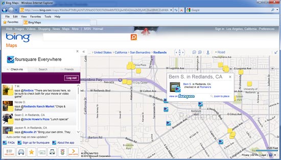
That's my location at the restaurant where I had dinner with friends last night.
Was that a little too much geo-social information? I could find the homes of some very distant Facebook "friends" on my list (why they would add their home as a check-in location is another issue). Would these distant "friends" really want to advertise where they live? Did I really need to know that a "friend" was at the dentist recently? Would a very casual acquaintance really want me to know that they hang out at Starbucks, frequent the local dive bar, go biking on Saturdays, and where they get their hair done? On the other hand, why would I, or anyone else for that matter, care?

As I scrutinized things I realized the friend locations were a bit out of date, and the scrolling marquee of tips and comments included lots from the generic "a foursquare user." And of course everyone has opt-out capabilities in announcing their whereabouts and can make decisions about who their friends are.

While I'll continue my quest to become mayor of my favorite morning coffee stop, I'm also thinking I'm going to be a little more aware of what I announce and selective about my friends. Perhaps most significantly, and thanks to Foursquare, I have now become more aware of my personal geo-social comfort zone.

Thursday, February 10, 2011

A Planning Maplication from the City of Dublin, Ohio

I discovered this application featured on the ArcGIS.com gallery pages the other day, and it's a great app with some very interesting features and capabilities. The application was was created by the city's GIS and planning staff to make community plans more widely available. According to the detailed description of the application:

This maplication includes graphic concepts and design recommendations developed for nine geographic areas as part of the Land Use Plan. Click an area plan title in the legend to zoom to a specific plan on the map. Hover over the icons on the map to see design recommendations and illustrations. Use the 'swipe' or 'spotlight' tools to view aerial imagery behind an area plan. Access the published versions of each area plan by clicking the PDF link in the legend.

What caught my eye in the thumbnail preview on the ArcGIS.com gallery was that the map didn't look like your usual map, and appeared more like a drawing. That was indeed true, as once I opened the app I found georeferenced plan diagrams on top of the aerial imagery basemap. The next thing I noticed was that it offered some very nice tools that let me examine the plans in the context of current geography. This is a really great idea, and a great app that was a snap to use.

A swipe tool enabled me to slice back and forth between the plan and the underlying imagery. The yellow arrow below points to the swipe line, and you can see the high resolution imagery underneath the plan:


A clever spotlight tool, with an adjustable spotlight size, let me peek through the plan to the underlying basemap. The yellow arrow below points to the spotlighted area:


You can enjoying the app yourself by opening it from the Dublin community plan maplications page.

Friday, February 4, 2011

Esri Super Bowl FanMap Goes Viral (more or less)

Could this end up being the most popular GIS-powered app to date? The Esri Super Bowl FanMap has gone viral, at least as viral as GIS ever goes. I just happened to notice it come up in a handful of tweets last night while online for only a short while. The interesting part was looking at the tweet authors, and realizing they have no association with GIS or even mapping. It seems that while GIS and geography might matter, football matters more.

Here's the map in case you're one of the few in the Esri camp that haven't seen it. Click to open it and cast your vote (and beer preference).


The app is powered by ArcGIS Server and is built using the ArcGIS API for Flex.

Thursday, February 3, 2011

Make An Easy Hazard Map

I'd almost forgotten about the Esri Mapping for Everyone site that has some nifty apps that enable you to quickly and easily make a demographic, health, or hazard map leveraging ArcGIS Online content.


I ran into it again this evening and made this quick live earthquake map using a service from the USGS Natural Hazards Support System (NHSS) showing events within the last 7 days. Try panning or zooming to your own place of interest.


You can embed the live map like I've done above, or make a more complete map that includes a title and your email and share it via a link, tweet, or Facebook.