Here's a sneak peek at something that we've been working on and will release very soon. It's the ability to drag and drop a CSV file onto your ArcGIS Online webmap.
This capability is already supported via one of the JavaScript sample applications (check it out) and will be part of the next round of updates to the webmap spec, meaning that it's supported in the ArcGIS.com map viewer and also ArcGIS Explorer Online. Your saved maps using CSV data can also be opened on your iPhone or iPad, and can be embedded in any website.
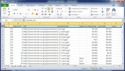
Here's our CSV file - it's a spreadsheet containing traffic cam locations with links to traffic cam snapshots that are updated every few minutes in Lincoln, Nebraska. Note that we've got the latitude and longitude for each cam, as well as the URL link to the latest cam snapshot.
To add the CSV file to the map, just drag and drop it:
The coordinates are automatically read from the CSV file, and instantly we have the locations on our map with the ability to click each of them to view other data from the CSV. This includes the link (the More info link shown in the pop-up) to the cam snapshot.
Configuring the pop-up window properties in the map viewer we can improve on the default. Below we've changed the symbols and also configured the pop-up window to display the current webcam snapshot directly in the pop-up.
And we can do everything else we can do with our map, including share it via a link,use it in an app template, or embed it in a website or blog post as shown below:
The above screenshots were made using the current development version of the map viewer, scheduled for public release prior to the upcoming Esri User Conference in early July. There's many other new features and capabilities which we'll cover on the ArcGIS Online blog and perhaps provide more previews of here.


